Flood Risk by US Region: Where Are You Most Vulnerable?
Flood risk is not evenly distributed across the United States. A homeowner in Houston faces completely different threats than one in Portland or Philadelphia. Knowing your region's specific flood patterns — the causes, the timing, and the scale — is the first step to protecting your home effectively.
This guide breaks down flood risk by major US region, covering the dominant flood types, the FEMA flood zones most common in each area, and the protection measures that matter most where you live.
Gulf Coast: America's Flood Epicenter
States: Louisiana, Texas, Mississippi, Alabama, Florida (western panhandle)
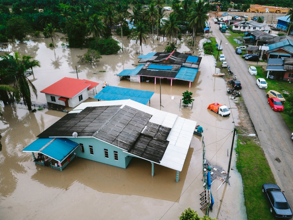
The Gulf Coast is the most flood-prone region in the United States. It faces three simultaneous threats: hurricane storm surge from the Gulf of Mexico, intense tropical rainfall, and riverine flooding from rivers draining the central US. Louisiana alone has more FEMA-designated Special Flood Hazard Areas (SFHAs) per square mile than any other state.
Primary Threats
- Storm surge: Hurricane Katrina's surge reached 28 feet in parts of Mississippi. Even a Category 1 storm can generate 4–5 foot surges that inundate coastal neighborhoods.
- Tropical rainfall: Hurricane Harvey dropped 60 inches of rain on parts of Houston in 2017 — the highest rainfall ever recorded from a US tropical cyclone. This overwhelmed even homes well outside the 100-year floodplain.
- River flooding: The Mississippi, Atchafalaya, and Red River systems create chronic flooding risk for interior Louisiana and Mississippi communities, even in non-hurricane years.
FEMA Flood Zones Common Here
Zone VE (coastal high hazard with wave action) and Zone AE (high-risk riverine) dominate Gulf Coast flood maps. If you're in Zone VE, mandatory flood insurance is required with a federally backed mortgage — and rates reflect the extreme risk. Zone X properties along the Gulf Coast have still flooded during major events like Harvey, which expanded the effective flood footprint far beyond mapped zones.
What Works Here
Foundation elevation is the primary defense — FEMA requires new construction in Zone AE to be built at or above the Base Flood Elevation (BFE). For existing homes, elevation retrofits can cost $30,000–80,000 but dramatically cut insurance premiums. Storm-rated flood barriers, backflow prevention, and above-flood-level utilities are essential. Check available FEMA mitigation grants through your state's hazard mitigation office.
Atlantic Seaboard: Nor'easters, Surge, and River Flooding
States: Florida (east coast), Georgia, South Carolina, North Carolina, Virginia, Maryland, Delaware, New Jersey, New York, Connecticut, Rhode Island, Massachusetts
The Atlantic Coast faces a unique combination of threats: hurricane and tropical storm surge from the south, nor'easter coastal flooding from the north, and widespread riverine flooding from the Appalachian watershed. Superstorm Sandy in 2012 caused $65 billion in damage — largely from surge flooding that extended miles inland across New Jersey and New York.
Primary Threats
- Hurricane surge (Southeast): Florida's Miami-Dade and Broward counties have extensive Zone VE coastlines. A direct major hurricane hit on Miami would be a catastrophic national event.
- Nor'easters (Northeast): Slow-moving winter storms pile water against the coast over 24–72 hours, generating surge even without hurricane-force winds. Boston and New York are particularly exposed.
- Appalachian river flooding: When tropical remnants stall over the mountains, rivers in the Carolinas, Virginia, and West Virginia can rise 20–30 feet. The French Broad River flooded Asheville, NC with historic force during Hurricane Helene in 2024.
- Tidal flooding: Sea level rise is making "sunny day flooding" (high-tide flooding with no storm) a recurring event in Annapolis, MD; Norfolk, VA; and Charleston, SC. Norfolk is sinking at 4.5mm/year while seas rise — creating compounding exposure.
What Works Here
In Zone VE coastal areas: foundation elevation, flood vents, and storm shutters. In riverine areas: sump pumps with battery backup, flood barriers, and elevated utilities. Tidal flooding zones need persistent drainage solutions — check with your local floodplain manager about tide gates and municipal drainage upgrades.
Midwest / Mississippi River Basin: Slow Rise, Big Damage
States: Iowa, Missouri, Illinois, Indiana, Ohio, Kentucky, Tennessee, Arkansas, Minnesota, Wisconsin
Midwestern flooding is typically riverine — slow-rising, driven by snowmelt and spring rainfall across the vast Mississippi, Ohio, Missouri, and Illinois river watersheds. The Great Flood of 1993 inundated 20 million acres across nine states, causing $15 billion in damage. The 2019 Missouri River floods were the worst in that river's recorded history.
Primary Threats
- Spring snowmelt flooding: A warm spring following heavy snowpack can raise major rivers 20–40 feet over several weeks. Communities along the Missouri, Mississippi, and Ohio Rivers face this risk almost annually.
- Flash flooding (urban and rural): Intense summer thunderstorms can overwhelm both urban stormwater systems and rural creek systems rapidly. Kansas City, St. Louis, and Cincinnati have significant flash flood exposure.
- Levee risk: Hundreds of miles of agricultural and residential levees along Midwestern rivers are aging, poorly maintained, or undersized for current risk levels. FEMA's levee accreditation system is failing many communities.
FEMA Flood Zones Common Here
Zone AE (riverine high-risk) and Zone AO (shallow flooding) are common. Many Midwestern communities have significant Zone X areas that have flooded in recent major events — confirming that flood maps often understate real risk when rivers breach levees or exceed historical high-water marks.
What Works Here
Sump pumps are non-negotiable in basement-heavy Midwestern homes. Backflow valves prevent sewer backup during major events. Portable flood barriers work well for riverine flooding because the slow rise gives you time to deploy them. Elevation of utilities — water heaters, electrical panels, HVAC — limits damage when water enters.
Pacific Northwest: Atmospheric Rivers and Rapid Runoff
States: Washington, Oregon, Northern California
The Pacific Northwest faces flooding primarily from atmospheric rivers — concentrated bands of moisture nicknamed "Pineapple Express" that can deliver 5–15 inches of rain in 24–48 hours. When this rainfall hits steep, saturated mountain slopes, rivers rise with extraordinary speed. The December 2021 atmospheric river event caused catastrophic flooding across Washington and British Columbia.
Primary Threats
- Atmospheric river flooding: Snohomish, Skagit, Chehalis, and Nooksack River valleys in Washington flood almost annually. Some communities have flooded 30+ times since the 1990s.
- Urban stormwater: Seattle and Portland's urban watersheds flood streets and basements when intense rainfall exceeds storm drain capacity.
- Debris flows: Burn scar areas from wildfires become extreme flash flood and debris flow hazards in subsequent rain seasons.
What Works Here
Because Pacific Northwest flooding can rise rapidly, pre-positioned barriers matter enormously. Early warning via the National Weather Service's river forecast system gives 12–48 hours notice for major river events. Sump pump systems with battery backup are essential for basement protection in high-rain areas.
Southeast Interior: Flash Floods and Karst Hazards
States: Georgia, Alabama, Mississippi, Tennessee, Arkansas, Kentucky
The interior Southeast is dominated by flash flood risk. Warm, moist air from the Gulf fuels intense convective storms that can drop 4–8 inches of rain in an hour. Tennessee experienced its worst-ever flash flood in Humphreys County in 2021 — 17 inches of rain in 24 hours.
What Works Here
Flash flood response requires pre-positioned defenses and early action. Sign up for NWS flood watches and Flash Flood Emergencies via Wireless Emergency Alerts. Keep barriers ready. Elevate critical utilities and valuables permanently — you may have 30 minutes to respond, not 30 hours.
Mountain West / Flash Flood Alley
States: Arizona, New Mexico, Nevada, Utah, Colorado
Desert flooding is counterintuitive but deadly. Hardpan soil in the Southwest can't absorb heavy rain quickly, causing runoff rates that exceed anything in wetter climates. Canyon topography concentrates water instantly. Monsoon season (July–September) brings afternoon thunderstorms that can cause catastrophic flash floods with zero warning downstream.
What Works Here
Never drive through flooded washes or dips — "turn around, don't drown" saves lives. For homes near arroyos or at canyon mouths, consult your county floodplain manager. Understanding your FEMA flood zone matters especially here because Zone AO designations are common and poorly understood by homeowners.
Know Your Risk, Build Your Defense
Regional knowledge is the starting point — but every property is different. The most important step you can take today is understanding your specific property's exposure. Check your personalized flood risk score — our tool analyzes your location, flood zone, and property characteristics to give you a risk rating and specific recommendations in under 3 minutes.
Once you know your risk level, explore the cost and ROI of common mitigation measures to build a protection plan that fits your budget. Every region has options — from a $200 barrier kit to a full foundation elevation. Start somewhere.